Comments on 0.10.1

Wow, this latest release is great! Love the maps and expanded fields.

Just a couple of recommendations (potentially a bug as well), on iOS:

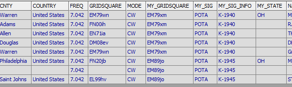
  • If no club call is entered, this version exports OPERATOR but not STATION_CALLSIGN. STATION_CALLSIGN should ALWAYS be exported. If a club callsign is entered in the template, then the STATION_CALLSIGN becomes the club call. But otherwise it is the same as my call.

  • We need the ability to enter MY_STATE (and preferably MY_COUNTY too), unless the app draws this from the grid square that is entered. Some parks (such as trails) span several states. Some national parks do, too.

  • For some reason, during a test run, when examining the exported ADI file, “MY_STATE” is only populated for the first QSO I entered. It didn’t get replicated to any of the others.

That’s all I see at first look. This is progressing very nicely!

1 Like

Thank you for this write up! I didn’t know about the operator vs station adif fields. I think I thought it was the other way around, but looking at the ADIF spec I think you’re right.

State and County will be coming the the expanded fields section soon.

But then I’m confused about what you meant in your 3rd bullet about “my state” not populating - that’s not a field I’ve included yet.

That’s odd. HAMRS is getting the MY_STATE field from somewhere. Here’s a screen shot of the ADIF:

image

I exited the log, went back in and entered three new QSOs. MY_STATE populated again for the first one but not for the others.

OH! I’m dumb. I pull it from the Park info from POTA.

That’s definitely odd it’s not continuing to do it. I’ll add it to my next bugfix relase.

Are you basing the state on the Park’s state, or the grid square data actually entered in the log?

Again, gotta consider multi-state parks…

It’s whatever POTA gives me for that park number, but yeah, not ideal for big parks. I think just exposing My State and County will be the best fix before GPS location is out.

This, for instance is what POTA supplies for that park.

   "reference": "K-1940",
   "name": "Caesar Creek State Park",
   "active": 1,
   "entityId": 291,
   "locationDesc": "US-OH",
   "latitude": 39.519,
   "longitude": -84.0245,
   "grid": "EM79xm"

So I thought, “Oh cool, I can just parse OH out of locationDesc and call it good.” Now I realize it’s probably only like 80% accurate.

Right, especially when it lists multiple states.

I think the best interim fix is to allow the user to enter his or her county and state.

The app could pre-populate these but allow a change, like it does for the other party’s location info.

Yeah, this is call. I’ll get it going. Thanks a TON for taking the time to think this out with me.

I love the app and deeply appreciate your willingness to flex & meet the needs of your customer base. Thanks for everything!

2 Likes